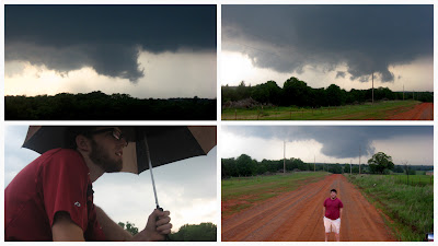
We loaded up and hit I-35 northbound around 1:30pm that Sunday. We targeted a location in northern Oklahoma based on the latest available information from the Storm Prediction Center and hourly models. As we drove, storms began initiating and quickly developing to our southwest. We pulled off, looked at radar, and made the decision to head south toward a supercell moving toward Edmond. As we got into town, the many trees and buildings on hills made it difficult to get a good vantage point. A spot was finally found at the entrance of LifeChurch.TV in Edmond and we watched the wall cloud and rain curtains closely for rotation. Around 4:20pm a weak tornado formed to our west (pictured). Later surveys would find EF1 damage in Edmond from this short-lived twister.
As the storm tracked east-northeastward across I-35, we moved to our east to get further ahead of the storm. Large volumes of traffic on the two lane road complicated our efforts but a glance out the window provided a glimpse of a new tornado forming around 4:25pm to our northwest.
The storm continued its track and our east-west oriented highway was becoming further and further displaced from the rotation. Terrain and numerous trees obscured views of the tornado that barreled toward Carney, Oklahoma. The tornado had also become rain-wrapped making us unsure of what we saw but we were fairly confident we caught glimpses of the twister. We tried to keep up with the tornadic storm but limited, unpaved county roads and suburban traffic made it nearly impossible. As the rotation weakened around 5:30pm, we turned our sights to the south as another supercell developed.
We dove south, ahead of the storm, and got into our prime position with a great viewing angle of a wall cloud to our west. We watched carefully for several minutes as it moved to the northwest then north of us, still above the ground.
The radar indicated circulation was too weak and the storm ended up not producing any tornados. Further to our south, another storm had been brewing over Norman. My wife, Veronica, and our puppy sought shelter at a friend's house as the tornado sirens blared throughout the city. Later, this storm generated an EF4 tornado that ripped through parts of Shawnee, Oklahoma and other small towns, northeast of Norman. Giving up on our weakening wall cloud, we headed south and east once again to get ahead of the next supercell.
As daylight faded and the storms weakened, we began our trek home, stopping in Henryetta, Oklahoma for a late dinner. The day had not been a wild success photographically but we saw two tornadoes and I had now seen three total in my five chases. But nothing prepared us for what was to come the next day...
For more photos, see my Google+ album here


No comments:
Post a Comment